| |
|
The political economy of development |
|
| Home- Themes- Reports- Statistics/Search- Lecture notes/News- People's Century- Puro Chile- Mapuche |
| Make your work easier and more efficient installing the rrojasdatabank toolbar ( you can customize it ) in your browser. |
|
| World indicators on the environment | World Energy Statistics - Time Series | Economic inequality |
|
The urban challenge in Africa: Growth and management of its large cities Edited by Carole Rakodi - United Nations University Press - TOKYO - NEW YORK - PARIS - ® The United Nations University, 1997 Communication and transportation networks The transportation network in Egypt was very limited for much of its history. In the late 1970s the length of roads in the whole country amounted to 16,139 km, of which only 25 per cent were paved, with a rate of 1 km to every 8,000 inhabitants. In the late 1980s and 1990s this rate increased to 1 km per 2,000 inhabitants, which is still less than in developed countries. Other means of communication and transportation such as railways and telephones were similarly underdeveloped. Most of the transportation routes radiate from Cairo, connecting it with other major centres of the country and adding to its centrality. The lack of well-developed transportation and communication systems made it difficult to diffuse development from Cairo to other parts of the country, thus maintaining the primacy of Cairo. Political factors The centralization of government in Egypt is a major factor in Cairo's rapid growth. Decision makers, government ministries and institutions, central offices for all Egyptian organizations, major investors, and elite groups that possess economic and political power are concentrated in Cairo and particularly in its distinguished high-class districts. Many studies (for example, Todaro, 1981) have discussed the role of the elite group in the concentration process, suggesting that:
In Egypt before 1952, the elite consisted of those of aristocratic origin and top bureaucrats related to colonization and the ruling system. After the 1952 revolution, the elite group consisted of the top military class, which ruled the country. Over time this has been transformed into a wider elite of families and social groups with close relations with the ruling system. These relationships have facilitated political power and wealth accumulation. For these reasons, the elite has concentrated in Cairo near the ruling class. From a prestige point of view, the government has emphasized the development of Cairo as Egypt's display window to the outside world. Extravagant services were concentrated in high-class districts and on major roads. Because public investments were concentrated in the core region (OCR) and not in peripheral regions, inequalities increased within the country. International relationships Recent studies suggest that a notable part of the growth of GCR is due to its international relations and its position within the world system. Egypt has been integrated into the world economy since the dawn of civilization owing to its strategic location at the centre of the old world. This integration became more evident in the nineteenth century with the opening of the Suez Canal, the expansion of the port of Alexandria, and the construction of Suez and Port Said ports. This integration was accompanied by a rapid increase in debts to foreign private banks, which ultimately led to direct intervention and occupation of the country by the British in 1882. Cairo became the administrative centre, with strong external links, especially to the colonial power. After the 1952 revolution and independence, the government's industrial development programme was based on high-technology and capital-intensive processes imported from the USSR and Eastern countries. In the 1970s, Egypt began its "open-door" policy aiming at attracting foreign investment, particularly from the United States and Western countries, as part of the process of shifting to a mixed economy. This period was marked by high inflation rates, sharp rises in imports, significant imbalances in both the trade account and government budgets, and, above all, growing foreign debt. Within Egypt, Cairo has been the centre of financial activities, housing multinational corporations and institutions, and has, as a result, become more and more integrated into the world economy. To fulfil this role, additional high-class residential areas, infrastructure facilities, and services were developed, reinforcing Cairo's growth and primacy. Recently, radical theorists have emphasized subsystems at the intermediate level, such as regions or a group of countries sharing similar characteristics (Wallerstein, 1974; Portes and Walton, 1981). Cairo in this respect is strongly interrelated with its surrounding regional subsystems: the Arab world, the Islamic world, and Africa. In the Arab world, Egypt is the largest country in terms of population and represents its heart. Cairo is the seat of almost half of the Arab political, economic, and cultural organizations, particularly in the Arab League, and an important banking centre. It provides military support to other Arab countries, as well as being a major source of labour (Findlay, 1994). The number of tourist nights spent in Egypt increased from under 1 million in the 1950s to an average of 18.6 million per annum in the late 1990s, and, of these, an average of 46 per cent between 1985 and 1990 were spent by Arab tourists, compared with 35 per cent in 1952 (see table 4.4). Cairo is also considered to be the cultural centre of the Arab world by most Arab states (Eddie Ibrahim, 1987). In the Islamic world, Cairo plays an extremely important role owing to the existence of Al-Azhar Mosque and University, which are the centre of Islamic knowledge. Extensive educational exchanges of students, professors, and preachers occur between Egypt and most Islamic countries. In Africa, Egypt has several times been elected as head of the Organization of African Unity, including twice in the past decade. Cairo is also the seat of many African political, economic, social, and sporting organizations. Deep-rooted economic relations tie Egypt with many African nations, particularly in the northern part of Africa. Finally, Egypt is related to many countries around the Mediterranean sea, such as Greece, France, Italy, and all the North African countries. Table 4.4 Tourist nights in Egypt by origin of tourists, 1952-1990 ('000)
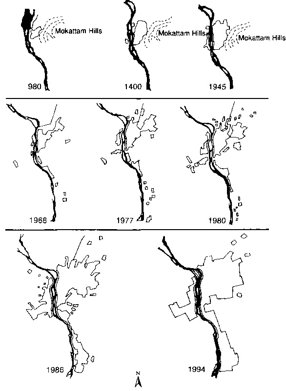
Physical development The built-up area of Cairo has fluctuated throughout its history, from a low of 5 km▓ (around A.D. 1200) to an estimated 184 km▓ at the peak of the Mamlouk period (A.D. 1200-1500). The city passed through periods of recession in the following centuries, with the result that its area had declined to about 15 km▓ at the beginning of the nineteenth century and 30 km▓ 50 years later. The districts adjacent to the old city, such as Boulak and El Azbakia, witnessed high rates of growth during this period and new districts appeared to the north, the north-east, and the west, such as Shubra, Abbasyia, Monira, Kasr El Nil, Tawfikia, and El Zatoon (Ibrahim, 1984; see fig. 4.4). Bridges across the Nile River were built to link Cairo to Giza, and Zamalek and Garden City became the favourite districts for the upper classes and foreigners. The introduction of a tramway in 1896 boosted the expansion of the city. Two new districts, Heliopolis (Misr El Gedida) and Maadi, were built to the north and south of the city to absorb the overflow of high-class districts at the beginning of the twentieth century (fig. 4.4). The area of the city reached almost 100 km▓ around 1950 (fig. 4.6). After the 1952 revolution, massive housing projects were built on the desert land east of the existing areas in Nasr city, to the south-east over the Mokattam hills, and to the south in new Maadi. The city also expanded on agricultural land to the south, linking Maadi and Helwan, and to the west of the Nile River in Giza. Helwan city was transformed from a high-class residential area to an industrial district housing most of the new heavy industries of Egypt. In Giza, new developments were planned to house middle-class professionals in single family homes, which were later torn down and transformed to high-rise buildings. To the north of the city and along major roads, housing and industries grew in the adjacent Qalyubia governorate. In the late 1970s the built-up area reached 350 km▓ (fig. 4.6) and many villages in the surrounding area were enclosed and absorbed. Fig. 4.6 Urban development of Cairo and the Greater Cairo Region, 980-1994
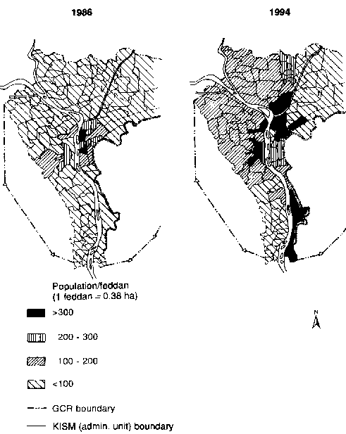
However, this physical expansion did not match the rapid population growth. Population densities rose to astounding levels. In 1966, densities in Bab-El Sharia district, situated in the oldest part of the city, reached 136,000 inhabitants per km▓ and in Rod El Farag, which was subject to heavy in-migration from the Delta, they reached 105,000/km▓. The overall density in Cairo ranged between 20,000 and 23,000 persons/km▓ between 1966 and 1970. Overall densities rose steadily in the next two decades to reach 32,000/km▓ in 1994, ranging from 109,000/km▓ in the most densely populated districts, to under 15,000/km▓ in the least (fig. 4.7). The density in the old districts has, however, not risen further during the past two decades as they have reached their ultimate capacities. There are many reasons for this astounding rise in densities. On the demand side, the majority of the population preferred to reside as near as possible to the city centre, where employment opportunities and services are available but where high housing prices led many families to share their units with others. On the supply side, the government was unable, because of financial and managerial limitations, to service sufficient urban land to keep pace with population growth. In addition, rent control laws led to slow growth of the housing stock. Land uses In 1982 the GCR was delineated by administrative boundaries encompassing 131,260 hectares, including the built-up area (32,609 ha), government property (11,219 ha), vacant land (839 ha), and agricultural land (86,593 ha). This area did not include the River Nile and desert land, which amounted to almost 130,000 hectares (GOPP, 1983, App. B). Residential land use thus accounted for 67 per cent of the total built-up area in 1983. Economic activities and service facilities shared the remaining area, with 17 per cent and 16 per cent respectively (see table 4.5). A closer look at the spatial distribution of land uses shows that in 1982, when the Giza section had attracted migrants from Cairo and other parts of the country, residential land use was dominant (74 per cent). Qalyubia section was, in contrast, characterized by the number of economic activities that were located in Shubra El-Khima and Mustorod (27 per cent of the total built-up area). Most of the services needed for the GCR were located in the Cairo section, followed by Giza (where Cairo University is located). The central business district (CBD) of Cairo is located between the old city and the Nile. However, during the 1980s and 1990s, commercial, retail, and business activities expanded to the west, in Zamalek, then in Mohandissin on the other side of the river. New centres also appeared in the north (Roxy Square) and in the south (in Maadi). Industrial uses were traditionally located in the old city in Cairo near the CBD. Because of the scarcity of land in these areas, however, since the 1960s large industrial sites have been established outside the built-up area to the north (Shubra El-Khima) and south (Helwan). Most of this industrial development took place on agricultural land and along major regional roads, consuming more than 85 ha per year. Old areas became specialized in small- and medium-scale industries and crafts, while new sites housed heavy industries and large warehouses. Today, industrial investors have used up most industrial sites in the new cities built around the GCR, particularly in 6 October new city in the west and 10 Ramadan new city to the north-east. Fig. 4.7 Population densities in the Greater Cairo Region, 1986 and 1994 (Sources: based on figures produced by CAPMAS for 1986 and Cairo governorate for 1994)
Table 4.5 Land use in the Greater Cairo Region, 1983 (ha)
Urban growth problems Owing to the polarization process in Egypt, large urban centres, and particularly Cairo, have suffered from serious urban problems, both physical and social. This section highlights some of these urban problems in the GCR: housing, transportation and infrastructure, and inequality. Housing Housing supply was mostly by the private sector until the late 1950s, when rent control laws were applied. A sizeable proportion of developers in the housing market, as a result, shifted their investment to other fields. After that, the public sector assumed a major role in housing supply through central and local government, development agencies, and public housing companies. The semi-public agencies helped in the production of housing units through housing cooperatives, the El-Awkaf Authority, banks, insurance companies, and the construction of housing for individual workers. The private sector diminished to a few individual landlords, owner-occupiers, and small development companies. Provision of infrastructure remained the responsibility of the government (see below). The total number of housing units built per year by both public and private sectors decreased from 56,000 units in the 1950s to fewer than 30,000 in the 1960s. Low- and medium-cost housing was financed by personal and family savings, loans from the General Organization for Housing Cooperatives and the Bank of Housing, as well as low-interest loans to governorates to finance public housing. The change in economic policy in the second half of the 1970s caused drastic changes in the housing market. The annual number of units built increased steadily to reach more than 180,000 in 1990. The role of the public sector diminished and was limited to the provision of low- and medium-cost units, mainly in the new towns and settlements around the GCR. Private investment in the housing and real estate sectors has increased continuously in the past two decades, despite the fact that these sectors are, in theory, tightly regulated and rent controlled and suffer from credit shortages. According to estimates by the Ministry of Housing and Reconstruction, private sector gross investment in housing grew from ŻE732 million in 1982/83 to ŻE2,950 million in 1991/92, representing more than 25 per cent of the total private investment in Egypt. On the other hand, public gross investment in housing fluctuated from ŻE67 million in 1982/83 to ŻE370 million in 1986/87 and back to ŻE91 million in 1991/92, representing less than 1 per cent of total Egyptian public investment. Similarly, gross value added in private sector housing rose from ŻE350 million in 1982/83 to ŻE2,223 million in 1991/92, whereas it increased only from ŻE62 million to ŻE127 million in public sector housing over the same period. In 1991/92, the private sector contributed 97 per cent of the total investment in housing and 95 per cent of the total value added in the housing sector. Factors that explain the burgeoning private sector investment in housing include the high levels of demand resulting from urban population growth. In addition, private sector developers find ways around the rent control laws, such as build-to-own arrangements, and cash advances paid to developers. The illegal/informal housing that represents a large portion of the Egyptian housing market is totally financed by private investment. Given the limited choice of alternative investments in the Egyptian market (especially during periods of recession), real estate is a major outlet for domestic savings and especially for the remittances of Egyptians working in oil-exporting Arab countries (World Bank, 1994; see also chap. 11). Informal housing, in the form of illegal subdivisions for low- and middle-income classes, is usually developed on the fringes of the built-up area. Such informal housing is built mostly on privately owned land (generally agricultural land) that is subdivided into small parcels without informing the local authorities and then sold to buyers without any legal deeds. Consequently, no building permits are issued. The magnitude of this process is far greater than the capacity of government authorities to organize or control it. The result is usually unplanned, high-density, and low-quality developments deprived of basic services and infrastructure. However, when such areas reach a population size large enough to exert political pressure, the government is forced to provide them with water, electricity, and sometimes sewerage networks. Squatting is less common, but occurs on the fringes of the built-up area, in and around tombs in the City of the Dead, and on rooftops. In the City of the Dead, adjacent to the Islamic core of Cairo, traditional burial places include a grave, one or two adjacent rooms, and an open yard surrounded by a fence, so that relatives of the deceased can pay extended visits. In the past four decades, the City of the Dead has been occupied by increasing numbers of permanent residents (250,000 in the mid-1980s) and the authorities have reluctantly extended services (Eddie Ibrahim, 1987). Peripheral squatter settlements, which are usually built on publicly owned or desert lands, are even worse than illegal subdivisions in terms of their lack of services and infrastructure, poor physical conditions, and high population densities. | ||||||||||||||||||||||||||||||||||||||||||||||||||||||||||||||||||||||||||||||||||||||||||||||||||||||||||||||||||||||||||||||||||||||||||||||||||||||||||||||||||||||||